


Product Description
GPSMAP® 1222 12-inch Keyed Networking Chartplotter - No Sonar (010-01741-00)
Elevate your marine navigation with the Garmin GPSMAP 1222 Keyed Networking Chartplotter — a feature-rich, all-in-one 12″ display designed for cruisers, racers, and serious sailors. This unit delivers advanced connectivity, fast positional updates, and seamless sharing of maps and sensors across your onboard network.
Key Features & Benefits
- 12″ WXGA color display + keypad control — a bright, large screen paired with a tactile keypad interface and multifunction control knob, plus user-programmable keys for quick access.
- High-sensitivity 10 Hz GPS & GLONASS — updates position and heading ten times per second for smooth motion on screen and precise waypoint tracking (up to 5,000 waypoints).
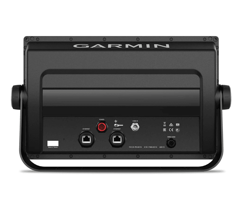
- Full networking support — connect and share data over Garmin Marine Network, NMEA 2000, and NMEA 0183 (input/output) for radar, sonar, autopilot, AIS, VHF, digital switching, IP cameras, and more.
- ANT wireless integration — pair with compatible devices including quatix marine watches, gWind Wireless 2, GNX Wind instruments, Garmin Nautix in-view displays, and remote controls.
- Built-in Wi-Fi & ActiveCaptain® support — wirelessly sync with the free ActiveCaptain app to plan routes, access updates, share charts (including Quickdraw Contours), and get smart notifications on your chartplotter.
- Chart expansion & Auto Guidance ready — dual SD card slots (up to 32 GB each) allow for map upgrades (LakeVü HD, BlueChart g2, g2 Vision HD) and enable Garmin’s patented Auto Guidance feature (for planning).
- SailAssist racing tools — built-in virtual starting line, laylines, time-to-burn, race timer sync across networked units; wind rose, true/apparent wind, set & drift, COG & heading lines.
- GPX interoperability — easily import/export waypoints, routes, and tracks in standard GPX format from other brands or Garmin handhelds.
-
Robust specs for marine conditions
- Rugged die-cast aluminum & polycarbonate construction with IPX7 water rating (submersible to 1 m for up to 30 min)
- Operates on 10–32 V DC power; typical 12 V draw about 2.4 A, max ~3.0 A
• Operating temperature range: –15 °C to 55 °C (5 °F to 131 °F)
• Dimensions: 33.0 × 22.6 × 7.9 cm (13.0 × 8.9 × 3.1 in)
• Weight: ~2.72 kg (6.0 lb)
- Complete in-box kit — includes chartplotter, power/data cable, NMEA-2000 T-connector + drop cable, bail mount kit, flush mount kit with gasket, protective cover, snap covers, trim pieces, and documentation.
Why Choose GPSMAP 1222 (No Sonar Edition)?
This version focuses on charting and networking capabilities without built-in sonar, making it ideal for users who already have sonar modules or black boxes. Its strong point is connectivity — sharing maps, radar, and sensor data across multiple displays and accessories — turning your helm into a cohesive marine electronics hub. Reviewers praise its clarity and responsive control knob for fast range adjustment.
0100174100
Quick Guide (pdf)
Owner's Manual (pdf)


Safe payment on our website
✔ Verified Reviews
- Choosing a selection results in a full page refresh.
- Opens in a new window.